Every culture has something else sacred - the Incas did it with the llamas. They immortalized the animals in a hidden city 3000 meters high in the Andes, not far from the famous Machu Picchu. Archaeologists found out: The whole complex points to a Lama constellation.
The ascent from the Andean village of Cachora to the ruins of Choqequirao takes almost two days. About 160 kilometers northwest of the ancient Inca capital of Cusco and 3,000 meters above sea level, there is a complex of more than 2,000 hectares that was only slightly inferior in grandeur to its famous neighbor Machu Picchu in its heyday.
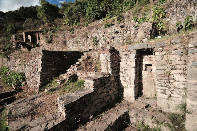
Today the visitor sees in the "Golden Cradle", as the name translates, terraces, squares, temples, fountains and canals overgrew with vegetation; only thirty percent of the city has been cleared of the undergrowth. In the 17th and 18th centuries, this place, which is described in Spanish documents as the silver city, was difficult to access and far from larger settlements and was of particular interest to treasure hunters. In 1847 the ruins then had distinguished visitors: the French diplomat Léonce Angrand indulged in archaeological interests and was the first to attempt to draw the city's floor plans. He rightly considered the settlement to be one of the last strongholds of the Inca against the Spaniards. The American Hiram Bingham undertook the first excavations there at the beginning of the 20th century, shortly before he discovered Machu Picchu. In the meantime, the Peruvian government has uncovered and restored some larger buildings in order to build an archaeological park. French archaeologists have been supporting the work for three years.
The Incas were the last Andean culture to emerge, establishing a farming state in the Cusco Valley in the 14th century. Only after the victory of King Pachacutec over the Chanca people around 1438 did they expand throughout Peru. To control the empire, Pachacutec and his successors built a network of cities and administrative centers, including Choqequirao.
Like other Inca cities, the site was divided into two: Hanan, the upper city, consisted of cult buildings around an open space, two-story warehouses and terraces with niches for cult images. In Hurin, the lower city, the elite probably lived in spacious buildings around a square and near a fountain. Hurin also had a temple and two large, oblong buildings interpreted as kallankas, halls for ritual dances and festivals. A flat-topped crest loomed over the lower town, perhaps a ceremonial platform (ushnu) on which sacrifices were made to the gods. A network of canals supplied the city with water that flowed down an aqueduct from the Yanacocha Glacier, 2,400 meters higher.
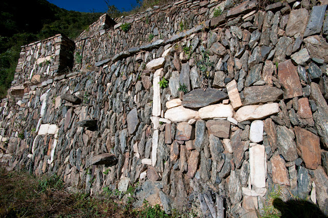
Due to the difficult terrain, the houses usually had only one rectangular room with a flat floor. Quarry stones were worked in such a way that they could be piled up without mortar, but sometimes they were jointed with clay. In this way, walls could be adapted to the undulating ground. Humpback stones also gave them a relief character. Also typical: trapezoidal doors, windows and niches.
The dwelling houses of the common people stood on the edge of the two parts of the city. From there it was not far to lower terraces where corn and the "Inca rice" quinoa, and perhaps also coca, were grown. It was precisely these simple dwellings, most of which are still hidden under dense vegetation, that surprised the researchers.
RELATED:
- Inca Empíre: All you need to know about the Inca history
- What does the Condor represent for Incas?
- Inca gods and goddesses
- Hiram Bingham Machu Picchu
- Tahuantinsuyo
- Llama vs alpaca vs vicuña vs guanaco
- Choquequirao to Machu Picchu trek
- Inca Trail tours
- Inca Trail
- Salkantay Trek


